User talk:DanielFilippi
Revision as of 16:06, 13 September 2021 by DanielFilippi (talk | contribs)
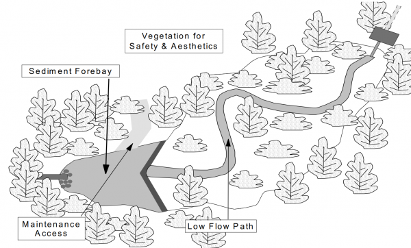
For Infiltration Trench[edit]
This infiltration trench features an inlet composed of filter fabric and decorative river stone, which provides some pretreatment and can easily be removed and replaced as part of routine sediment removal maintenance. For more details click here.
For Downspout disconnection[edit]
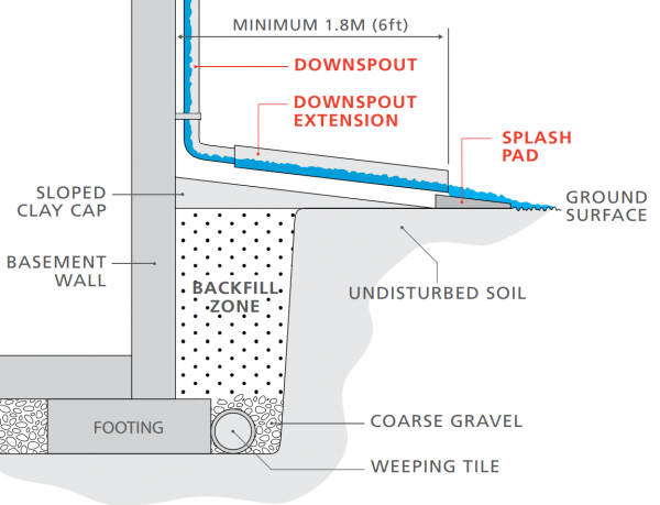
This schematic shows proper downspout disconnection of a building's downspout system with associated setback distances and items (weeping tile pipes, gravel, splash pad, etc. For more details click here.[1]
Dry pond[edit]
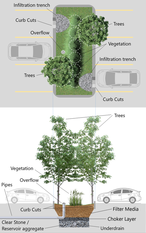
For Bioretention[edit]
   <area target="" alt="Curb Cuts" title="Curb Cuts" href="Curb cuts" coords="349,324,455,370" shape="rect">
   <area target="" alt="Infiltration Trench" title="Infiltration Trench" href="Infiltration trench" coords="342,186,487,230" shape="rect">
   <area target="" alt="Trees" title="Trees" href="Trees" coords="386,61,457,103" shape="rect">
   <area target="" alt="Overflow" title="Overflow" href="Overflow" coords="87,96,187,138" shape="rect">
   <area target="" alt="Vegetation" title="Vegetation" href="Plant lists" coords="365,132,476,177" shape="rect">
   <area target="" alt="Trees" title="Trees" href="Trees" coords="65,234,146,284" shape="rect">
   <area target="" alt="Trees" title="Trees" href="Trees" coords="386,384,464,428" shape="rect">
   <area target="" alt="Vegetation" title="Vegetation" href="Plant lists" coords="18,559,133,609" shape="rect">
   <area target="" alt="Overflow" title="Overflow" href="Overflow" coords="60,611,145,652" shape="rect">
   <area target="" alt="Overflow Pipe" title="Overflow Pipe" href="Pipes" coords="0,628,58,674" shape="rect">
   <area target="" alt="Curb Cuts" title="Curb Cuts" href="Curb cuts" coords="63,712,163,751" shape="rect">
   <area target="" alt="Clear Stone / Reservoir aggregate" title="Clear Stone / Reservoir aggregate" href="Reservoir aggregate" coords="0,759,165,816" shape="rect">
   <area target="" alt="Filter Media" title="Filter Media" href="Bioretention: Filter media" coords="386,714,501,747" shape="rect">
   <area target="" alt="Choker Layer" title="Choker Layer" href="Choker layer" coords="372,750,500,786" shape="rect">
   <area target="" alt="Underdrain" title="Underdrain" href="Underdrain" coords="347,788,454,816" shape="rect">
References[edit]
- ↑ The Institute For Catastrophic Loss Reduction. Protect your home from Basement flooding: Designed for safer living®. https://www.iclr.org/wp-content/uploads/PDFS/protect-your-home-from-basement-flooding.pdf. 2011. Accessed 3 September, 2021
- ↑ Ministry of the Environment. Stormwater Management Planning and Design Manual. https://dr6j45jk9xcmk.cloudfront.net/documents/1757/195-stormwater-planning-and-design-en.pdf. 2003. Accessed 3 September, 2021