Difference between revisions of "User talk:DanielFilippi"
Jump to navigation
Jump to search
| Line 41: | Line 41: | ||
<imagemap> | <imagemap> | ||
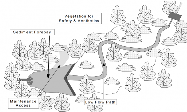
| − | Image:Dry pond.PNG|thumb|600 px|The following image showcases | + | Image:Dry pond.PNG|thumb|600 px|The following image showcases an illustrates an extended detention dry pond. For more details click [https://dr6j45jk9xcmk.cloudfront.net/documents/1757/195-stormwater-planning-and-design-en.pdf here.]<ref> Ministry of the Environment. Stormwater Management Planning and Design Manual. https://dr6j45jk9xcmk.cloudfront.net/documents/1757/195-stormwater-planning-and-design-en.pdf. 2003. Accessed 3 September, 2021</ref> |
rect 74 219 409 265 [[Pretreatment features| Sediment Forebays]] | rect 74 219 409 265 [[Pretreatment features| Sediment Forebays]] | ||
| Line 50: | Line 50: | ||
</imagemap> | </imagemap> | ||
| + | |||
| + | |||
| + | ==For Bioretention== | ||
| + | |||
| + | <imagemap> | ||
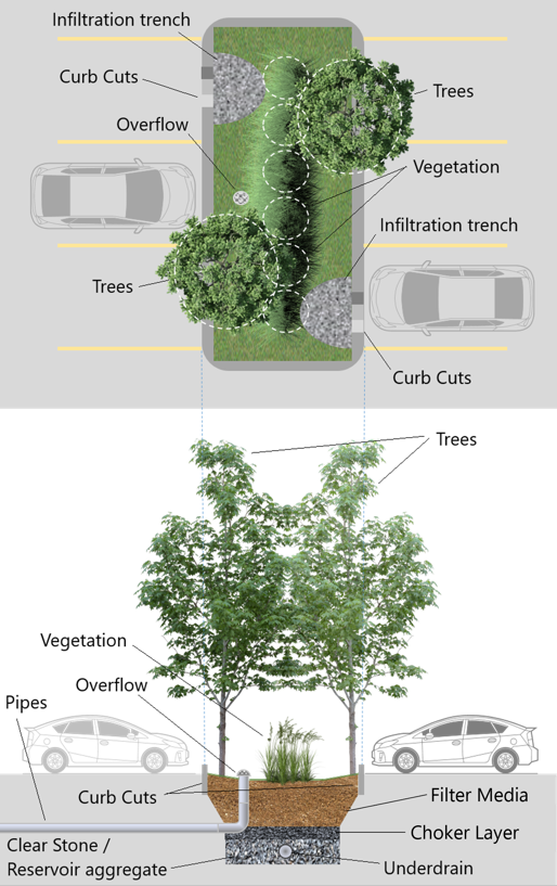
| + | Image:Bioretention Labeled low quality.PNG|thumb|600 px|This joint schematic with both Plan and Longitudinal Section views shows what a general biortention swale in a parking lot could look like. | ||
| + | |||
| + | rect 32 2 193 39 [[Infiltration trench| Infiltration Trench]] | ||
| + | rect 42 50 146 88 [[Curb cuts| Curb Cuts]] | ||
| + | |||
| + | </imagemap> | ||
| + | |||
| + | <area target="" alt="Curb Cuts" title="Curb Cuts" href="Curb cuts" coords="349,324,455,370" shape="rect"> | ||
| + | <area target="" alt="Infiltration Trench" title="Infiltration Trench" href="Infiltration trench" coords="342,186,487,230" shape="rect"> | ||
| + | <area target="" alt="Trees" title="Trees" href="Trees" coords="386,61,457,103" shape="rect"> | ||
| + | <area target="" alt="Overflow" title="Overflow" href="Overflow" coords="87,96,187,138" shape="rect"> | ||
| + | <area target="" alt="Vegetation" title="Vegetation" href="Plant lists" coords="365,132,476,177" shape="rect"> | ||
| + | <area target="" alt="Trees" title="Trees" href="Trees" coords="65,234,146,284" shape="rect"> | ||
| + | <area target="" alt="Trees" title="Trees" href="Trees" coords="386,384,464,428" shape="rect"> | ||
| + | <area target="" alt="Vegetation" title="Vegetation" href="Plant lists" coords="18,559,133,609" shape="rect"> | ||
| + | <area target="" alt="Overflow" title="Overflow" href="Overflow" coords="60,611,145,652" shape="rect"> | ||
| + | <area target="" alt="Overflow Pipe" title="Overflow Pipe" href="Pipes" coords="0,628,58,674" shape="rect"> | ||
| + | <area target="" alt="Curb Cuts" title="Curb Cuts" href="Curb cuts" coords="63,712,163,751" shape="rect"> | ||
| + | <area target="" alt="Clear Stone / Reservoir aggregate" title="Clear Stone / Reservoir aggregate" href="Reservoir aggregate" coords="0,759,165,816" shape="rect"> | ||
| + | <area target="" alt="Filter Media" title="Filter Media" href="Bioretention: Filter media" coords="386,714,501,747" shape="rect"> | ||
| + | <area target="" alt="Choker Layer" title="Choker Layer" href="Choker layer" coords="372,750,500,786" shape="rect"> | ||
| + | <area target="" alt="Underdrain" title="Underdrain" href="Underdrain" coords="347,788,454,816" shape="rect"> | ||
| + | |||
| + | |||
| + | |||
==References== | ==References== | ||
Revision as of 16:06, 13 September 2021
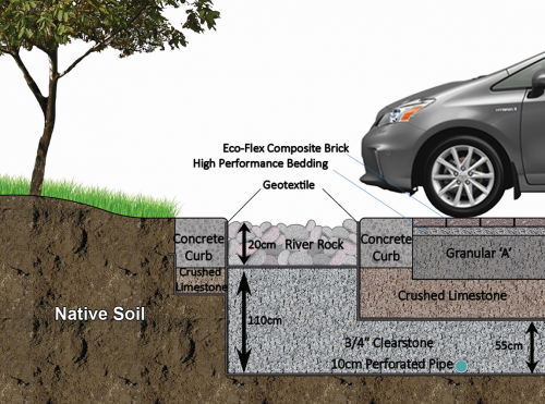
For Infiltration Trench[edit]
This infiltration trench features an inlet composed of filter fabric and decorative river stone, which provides some pretreatment and can easily be removed and replaced as part of routine sediment removal maintenance. For more details click here.
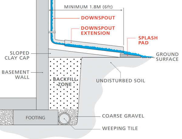
For Downspout disconnection[edit]
This schematic shows proper downspout disconnection of a building's downspout system with associated setback distances and items (weeping tile pipes, gravel, splash pad, etc. For more details click here.[1]
Dry pond[edit]
For Bioretention[edit]
   <area target="" alt="Curb Cuts" title="Curb Cuts" href="Curb cuts" coords="349,324,455,370" shape="rect">
   <area target="" alt="Infiltration Trench" title="Infiltration Trench" href="Infiltration trench" coords="342,186,487,230" shape="rect">
   <area target="" alt="Trees" title="Trees" href="Trees" coords="386,61,457,103" shape="rect">
   <area target="" alt="Overflow" title="Overflow" href="Overflow" coords="87,96,187,138" shape="rect">
   <area target="" alt="Vegetation" title="Vegetation" href="Plant lists" coords="365,132,476,177" shape="rect">
   <area target="" alt="Trees" title="Trees" href="Trees" coords="65,234,146,284" shape="rect">
   <area target="" alt="Trees" title="Trees" href="Trees" coords="386,384,464,428" shape="rect">
   <area target="" alt="Vegetation" title="Vegetation" href="Plant lists" coords="18,559,133,609" shape="rect">
   <area target="" alt="Overflow" title="Overflow" href="Overflow" coords="60,611,145,652" shape="rect">
   <area target="" alt="Overflow Pipe" title="Overflow Pipe" href="Pipes" coords="0,628,58,674" shape="rect">
   <area target="" alt="Curb Cuts" title="Curb Cuts" href="Curb cuts" coords="63,712,163,751" shape="rect">
   <area target="" alt="Clear Stone / Reservoir aggregate" title="Clear Stone / Reservoir aggregate" href="Reservoir aggregate" coords="0,759,165,816" shape="rect">
   <area target="" alt="Filter Media" title="Filter Media" href="Bioretention: Filter media" coords="386,714,501,747" shape="rect">
   <area target="" alt="Choker Layer" title="Choker Layer" href="Choker layer" coords="372,750,500,786" shape="rect">
   <area target="" alt="Underdrain" title="Underdrain" href="Underdrain" coords="347,788,454,816" shape="rect">
References[edit]
- ↑ The Institute For Catastrophic Loss Reduction. Protect your home from Basement flooding: Designed for safer living®. https://www.iclr.org/wp-content/uploads/PDFS/protect-your-home-from-basement-flooding.pdf. 2011. Accessed 3 September, 2021
- ↑ Ministry of the Environment. Stormwater Management Planning and Design Manual. https://dr6j45jk9xcmk.cloudfront.net/documents/1757/195-stormwater-planning-and-design-en.pdf. 2003. Accessed 3 September, 2021