Difference between revisions of "User talk:DanielFilippi"
Jump to navigation
Jump to search
| Line 86: | Line 86: | ||
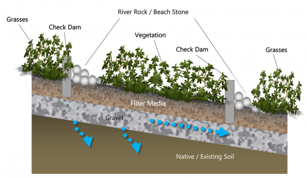
rect 334 371 447 427 [[Aggregates| Gravel]] | rect 334 371 447 427 [[Aggregates| Gravel]] | ||
rect 560 491 819 574 [[Soil groups| Native Existing Soil]] | rect 560 491 819 574 [[Soil groups| Native Existing Soil]] | ||
| + | |||
| + | </imagemap> | ||
| + | |||
| + | ==For Enhanced Swales== | ||
| + | |||
| + | <imagemap> | ||
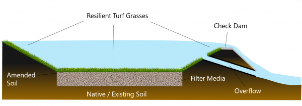
| + | Image:Enhanced Swale Labeled.PNG|thumb|600 px|The longitudinal schematic above shows a standard enhanced swale with amended soil, resilient turf grasses, filter media and optional check dams with a flow concentrating cutout to facilitate short term ponding and maximize infiltration capacity for this BMP installation. | ||
| + | |||
| + | rect 28 330 187 453 [[Absorbent landscapes| Amended Soil]] | ||
| + | rect 407 427 760 494 [[Soil groups| Native / Existing Soil]] | ||
| + | rect 411 42 744 123 [[Turf| Resilient Turf Grasses]] | ||
| + | rect 1030 75 1250 166 [[Check dams| Check Dam]] | ||
| + | rect 911 353 1122 424 [[Bioretention: Filter media| Filter Media]] | ||
| + | rect 1148 411 1318 490 [[Overflow| Flow Concentrating Cutout]] | ||
</imagemap> | </imagemap> | ||
Revision as of 16:16, 14 September 2021
For Infiltration Trench[edit]

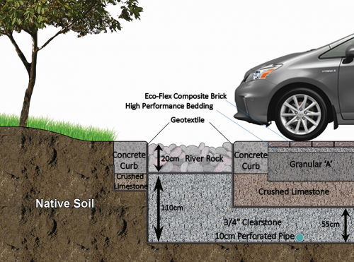
This infiltration trench features an inlet composed of filter fabric and decorative river stone, which provides some pretreatment and can easily be removed and replaced as part of routine sediment removal maintenance. For more details click here.
For Downspout disconnection[edit]

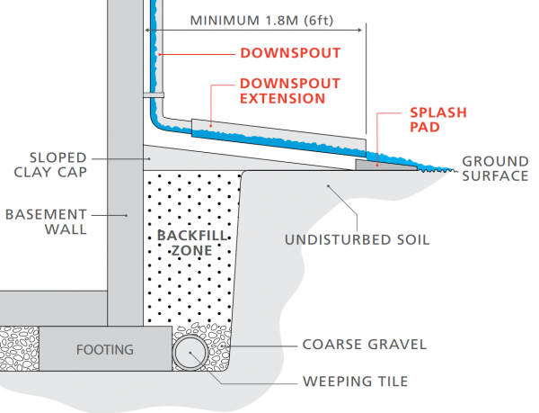
This schematic shows proper downspout disconnection of a building's downspout system with associated setback distances and items (weeping tile pipes, gravel, splash pad, etc. For more details click here.[1]
For Dry pond[edit]
For Bioretention[edit]
For Bioswales[edit]
For Enhanced Swales[edit]
References[edit]
- ↑ The Institute For Catastrophic Loss Reduction. Protect your home from Basement flooding: Designed for safer living®. https://www.iclr.org/wp-content/uploads/PDFS/protect-your-home-from-basement-flooding.pdf. 2011. Accessed 3 September, 2021
- ↑ Ministry of the Environment. Stormwater Management Planning and Design Manual. https://dr6j45jk9xcmk.cloudfront.net/documents/1757/195-stormwater-planning-and-design-en.pdf. 2003. Accessed 3 September, 2021
