Difference between revisions of "Erosion and Sediment Control"
ChristineLN (talk | contribs) |
ChristineLN (talk | contribs) |
||
| (59 intermediate revisions by the same user not shown) | |||
| Line 1: | Line 1: | ||
| − | |||
{{float right|{{#widget:YouTube|id=tZ3FhlciiKU}}}} | {{float right|{{#widget:YouTube|id=tZ3FhlciiKU}}}} | ||
{{TOClimit|4}} | {{TOClimit|4}} | ||
| Line 5: | Line 4: | ||
==Overview== | ==Overview== | ||
| − | [[File:Screenshot 2025-07-29 102005.png|250px|thumb|right|Effective ESC starts before topsoil stripping begins. This flow chart shows the ESC process from construction project start to finish. Scroll through the wiki to read about each step of the process.]] | + | [[File:Screenshot 2025-07-29 102005.png|250px|thumb|right|Effective ESC starts before [[topsoil]] stripping begins. This flow chart shows the ESC process from construction project start to finish. Scroll through the wiki to read about each step of the process.]] |
| − | [[Erosion]] and [[Sedimentation|sediment]] controls (ESC) are technologies, practices and procedures that are applied to prevent the release of sediment from construction sites. | + | [[Erosion]] and [[Sedimentation|sediment]] controls (ESC) are technologies, practices and procedures that are applied to prevent the release of sediment from construction sites. Rapid urban expansion and associated construction activities are a significant source of stress to the natural environment. As construction processes involve the removal of [[vegetation]] and de-stabilization of soils, they can accelerate natural processes of [[erosion]] and [[sedimentation]], mobilizing more sediment and associated [[Water Quality|contaminants]] that can ultimately end up in downstream receiving water systems. ESC measures are essential to help reduce these sediment loads from active construction sites and protect downstream aquatic habitats from becoming impaired. |
| − | Rapid urban expansion and associated construction activities are a significant source of stress to the natural environment. As construction processes involve the removal of vegetation and de-stabilization of soils, they can accelerate natural processes of erosion and sedimentation, mobilizing more sediment and associated contaminants that can ultimately end up in downstream receiving water systems. ESC measures are essential to help reduce these sediment loads from active construction sites and protect downstream aquatic habitats from becoming impaired. | ||
{{textbox|Inadequate ESC during construction can cause: | {{textbox|Inadequate ESC during construction can cause: | ||
| − | *sediment-laden runoff to enter downstream and adjacent natural features, including streams, lakes, wetlands and woodlots; | + | *sediment-laden runoff to enter downstream and adjacent natural features, including streams, lakes, [[wetlands]] and woodlots; |
*deposition of sediment on adjacent private property and roadways; | *deposition of sediment on adjacent private property and roadways; | ||
| − | *clogging of onsite stormwater management systems and LIDs; | + | *[[clogging]] of onsite stormwater management systems and LIDs; |
*expensive cleanup and restoration costs; | *expensive cleanup and restoration costs; | ||
*delays or stop-work orders; and | *delays or stop-work orders; and | ||
*fines from regulatory agencies.}} | *fines from regulatory agencies.}} | ||
| − | Implementing effective ESC practices throughout all stages of construction is essential to sustainable urban growth and ensuring regulatory compliance. | + | Implementing effective ESC practices throughout all stages of construction is essential to sustainable [[Urbanization|urban growth]] and ensuring regulatory compliance. |
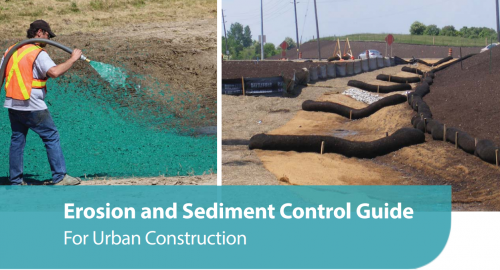
| − | [[File:Screenshot 2025-11-07 105736.png|500px|thumb| | + | [[File:Screenshot 2025-11-07 105736.png|500px|thumb|left|link=http://sustainabletechnologies.ca/app/uploads/2020/01/ESC-Guide-for-Urban-Construction_FINAL.pdf|The Toronto and Region Conservation Authority, through STEP, published the [http://sustainabletechnologies.ca/app/uploads/2020/01/ESC-Guide-for-Urban-Construction_FINAL.pdf Erosion and Sediment Control Guide for Urban Construction] in 2019. This wiki page summarizes key content from the guide and provides additional resources; however, readers should consult the full guide for comprehensive information. Click on the image to access the guide (STEP, 2019) <ref>STEP. 2019. Erosion and Sediment Control Guide for Urban Construction. https://sustainabletechnologies.ca/app/uploads/2020/01/ESC-Guide-for-Urban-Construction_FINAL.pdf</ref>.]] |
<br clear="all" /> | <br clear="all" /> | ||
| Line 33: | Line 31: | ||
| − | The hybrid qualitative ERA approach is recommended in the above situations, except where local regulatory agencies require a different approach. The hybrid qualitative ERA approach estimates erosion risk by dividing a site into areas based on soil, slope, and ground cover, then rating each area as low, moderate, or high [[Erosion#Erosion_potential|erosion risk]] to help choose the right erosion control practices for each stage of construction. Completing an ERA demonstrates due diligence, identifies high-risk areas early, informs effective BMP selection and placement, guides the use of enhanced controls, and provides context for decision-making. To learn more about ERAs, read section 6.2 in the [http://sustainabletechnologies.ca/app/uploads/2020/01/ESC-Guide-for-Urban-Construction_FINAL.pdf Erosion and Sediment Control Guide for Urban Construction] (2019) | + | The hybrid qualitative ERA approach is recommended in the above situations, except where local regulatory agencies require a different approach. The hybrid qualitative ERA approach estimates [[Erosion#Erosion_potential|erosion risk]] by dividing a site into areas based on [[soil groups|soil]], [[slope]], and ground cover, then rating each area as low, moderate, or high [[Erosion#Erosion_potential|erosion risk]] to help choose the right erosion control practices for each stage of construction. Completing an ERA demonstrates due diligence, identifies high-risk areas early, informs effective BMP selection and placement, guides the use of enhanced controls, and provides context for decision-making. To learn more about ERAs, read section 6.2 in the [http://sustainabletechnologies.ca/app/uploads/2020/01/ESC-Guide-for-Urban-Construction_FINAL.pdf Erosion and Sediment Control Guide for Urban Construction] (2019). |
==ESC plan design== | ==ESC plan design== | ||
| Line 44: | Line 42: | ||
#Final stabilization/rehabilitation and ESC decommissioning}} | #Final stabilization/rehabilitation and ESC decommissioning}} | ||
| − | An ESC plan should include drawings, standard notes and reports depicting and describing the site conditions (e.g. grades, locations of natural features, soil stockpiles and other key points of interest) during each phase of construction, and the BMPs that will be | + | An ESC plan should include drawings, standard notes and reports depicting and describing the site conditions (e.g. [[grading|grades]], locations of natural features, [[soil]] stockpiles and other key points of interest) during each phase of construction, and the BMPs that will be |
applied to mitigate erosion and sediment transport. | applied to mitigate erosion and sediment transport. | ||
| Line 63: | Line 61: | ||
| − | Table 1 and 2 provide an overview of common erosion and sediment controls. Click on the BMP name in the first column to read the detailed design requirements and installation, inspection, maintenance, and decommissioning guidance from the [http://sustainabletechnologies.ca/app/uploads/2020/01/ESC-Guide-for-Urban-Construction_FINAL.pdf 2019 Erosion and Sediment Control Guide for Urban Construction]. A description and common applications of each practice are listed in the second and third columns, respectively. The fourth column provides | + | Table 1 and 2 provide an overview of common erosion and sediment controls. Click on the BMP name in the first column to read the detailed design requirements and installation, inspection, maintenance, and decommissioning guidance from the [http://sustainabletechnologies.ca/app/uploads/2020/01/ESC-Guide-for-Urban-Construction_FINAL.pdf 2019 Erosion and Sediment Control Guide for Urban Construction]. A description and common applications of each practice are listed in the second and third columns, respectively. The fourth column provides additional resources and the fifth column shows an example image of the BMP. |
| − | Good and | + | |
| + | Good and poor examples of ESC installation are shown on the right side. Additional examples can be found on the [[Pre-construction#Erosion_and_sediment_control_measures|pre-construction wiki]]. | ||
====Erosion controls==== | ====Erosion controls==== | ||
| − | [[File:Screenshot 2025-11-13 102825.png|400px|thumb|right]] | + | [[File:Screenshot 2025-11-13 102825.png|400px|thumb|right|An interceptor swale should be stabilized with a suitable erosion control BMP (e.g., vegetation or RECP), particularly if it will be in place for more than 30 days. In order to reduce the potential for swale erosion and provide opportunity for sediment settling, flow interruption devices (e.g. check dams, filter socks, coir logs) should be properly installed within the swales.]] |
[[File:Screenshot 2025-11-12 162221.png|400px|thumb|right|Rolled erosion control products (RECP) should be installed according to manufacturer instructions. In general, RECP on steep slopes should be installed down the slope, extend to the top of the slope, use an anchor trench at top and bottom, be in continuous contact with soil surface and overlap. RECP installed in ditches/channels should be installed parallel to flow direction, be anchored to top of slope on both sides, be in continuous contact with soil surface, and overlap. Air pockets between the RECP and soil will allow stormwater to pass through and erode the soil below. | [[File:Screenshot 2025-11-12 162221.png|400px|thumb|right|Rolled erosion control products (RECP) should be installed according to manufacturer instructions. In general, RECP on steep slopes should be installed down the slope, extend to the top of the slope, use an anchor trench at top and bottom, be in continuous contact with soil surface and overlap. RECP installed in ditches/channels should be installed parallel to flow direction, be anchored to top of slope on both sides, be in continuous contact with soil surface, and overlap. Air pockets between the RECP and soil will allow stormwater to pass through and erode the soil below. | ||
| Line 78: | Line 77: | ||
! Description | ! Description | ||
! Applicability | ! Applicability | ||
| − | ! Additional Resources | + | ! Drawings and Additional Resources |
! Example Image | ! Example Image | ||
|- | |- | ||
| Line 84: | Line 83: | ||
| Preservation of vegetated areas intercepts and infiltrates rainfall. | | Preservation of vegetated areas intercepts and infiltrates rainfall. | ||
| Areas not being immediately developed on larger sites (>10 ha) | | Areas not being immediately developed on larger sites (>10 ha) | ||
| − | | | + | | |
| + | [[Media:MINIMIZED_OR_PHASED_LAND_CLEARINGdrawing.pdf|Tree Protection Barrier]] | ||
| | | | ||
[[File:Phased land clearing.png|200px|frameless|center]] | [[File:Phased land clearing.png|200px|frameless|center]] | ||
| Line 114: | Line 114: | ||
*Adjacent to valley/stream corridors | *Adjacent to valley/stream corridors | ||
| | | | ||
| + | [[Media:Screenshot 2025-11-19 101444.png|Interceptor Swale Diagram]] | ||
| | | | ||
[[File:Screenshot 2025-07-30 164042.png|200px|frameless|center]] | [[File:Screenshot 2025-07-30 164042.png|200px|frameless|center]] | ||
| Line 121: | Line 122: | ||
| Energy dissipation devices or surface hardening that prevents scour erosion at outlets. | | Energy dissipation devices or surface hardening that prevents scour erosion at outlets. | ||
| Base of any outlet releasing concentrated flow | | Base of any outlet releasing concentrated flow | ||
| − | | [https://feng.stafpu.bu.edu.eg/Civil%20Engineering/2476/publications/Mohammad%20Mahmoud%20Mohammad%20Ibrahim_ZJ0608295304.pdf Baffle shapes and size analysis] | + | | |
| + | [[Media:Screenshot 2025-11-19 101806.png|Storm Drain Outfall Protection Diagram]] | ||
| + | |||
| + | [https://feng.stafpu.bu.edu.eg/Civil%20Engineering/2476/publications/Mohammad%20Mahmoud%20Mohammad%20Ibrahim_ZJ0608295304.pdf Baffle shapes and size analysis] | ||
| | | | ||
[[File:Screenshot 2025-07-31 105113.png|200px|frameless|center]] | [[File:Screenshot 2025-07-31 105113.png|200px|frameless|center]] | ||
| Line 157: | Line 161: | ||
*In conjunction with mulching/seeding | *In conjunction with mulching/seeding | ||
| | | | ||
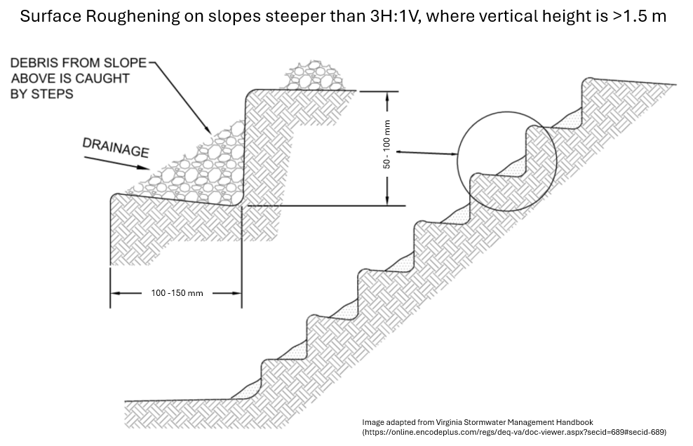
| + | [[Media:Screenshot 2025-11-19 104410.png|Surface roughening diagram for slopes steeper than 3H:1V and H > 1.5 m]] | ||
| + | |||
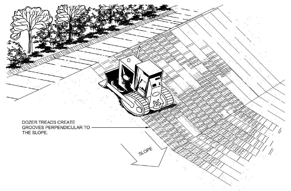
| + | [[Media:Surface roughening dozer.png|Surface roughening for slopes steeper than 2H:1V using bulldozer (Virginia Department of Environmental Quality)<ref>Virginia Department of Environmental Quality. Virginia Stormwater Management Handbook Version 1.1. https://online.encodeplus.com/regs/deq-va/doc-viewer.aspx?secid=689#secid-689</ref>]] | ||
| | | | ||
[[File:Screenshot 2025-07-30 164229.png|200px|frameless|center]] | [[File:Screenshot 2025-07-30 164229.png|200px|frameless|center]] | ||
| Line 171: | Line 178: | ||
*Erosion scars | *Erosion scars | ||
| | | | ||
| + | [[Media:B1 ROLLED EROSION CONTROL PRODUCTSdrawing.pdf|RECP Installation Diagram]] | ||
| | | | ||
[[File:Screenshot 2025-07-31 121353.png|200px|frameless|center]] | [[File:Screenshot 2025-07-31 121353.png|200px|frameless|center]] | ||
| Line 192: | Line 200: | ||
changed when required, the area underneath is stabilized, and that there is a stable flow path from the bag to the receiver. Monitor to ensure discharge is clean and no | changed when required, the area underneath is stabilized, and that there is a stable flow path from the bag to the receiver. Monitor to ensure discharge is clean and no | ||
erosion is occurring.]] | erosion is occurring.]] | ||
| + | |||
| + | [[File:Screenshot 2025-11-13 112507.png|400px|thumb|right|Protection, such as filter socks, should be installed around inlets. Filter socks should be staked whenever possible to prevent shifting, or reinforced with a board.]] | ||
{| class="wikitable" | {| class="wikitable" | ||
| Line 198: | Line 208: | ||
! Description | ! Description | ||
! Applicability | ! Applicability | ||
| − | ! Additional Resources | + | ! Drawings and Additional Resources |
! Example Image | ! Example Image | ||
|- | |- | ||
| Line 211: | Line 221: | ||
*Parallel to areas with sediment laden sheet flow | *Parallel to areas with sediment laden sheet flow | ||
| | | | ||
| + | [[Media:B2 SEDIMENT CONTROL FENCE unfrozen.pdf|Sediment control fence (unfrozen)]] | ||
| + | |||
| + | [[Media:B2 SEDIMENT CONTROL FENCE frozen.pdf|Sediment control fence (frozen)]] | ||
| | | | ||
| + | [[File:Screenshot 2025-11-13 131335.png|200px|frameless|center]] | ||
|- | |- | ||
| Line 225: | Line 239: | ||
*in place of sediment fence when frozen | *in place of sediment fence when frozen | ||
| [https://sourcetostream.com/2025-track-2-day-1-anderton/ S2S Conference Presentation] | | [https://sourcetostream.com/2025-track-2-day-1-anderton/ S2S Conference Presentation] | ||
| + | |||
[https://sustainabletechnologies.ca/home/erosion-and-sediment-control/permeable-barriers/compost-biofilters-for-stormwater-management/ Compost Biofilters for SWM (TRCA, 2007)] | [https://sustainabletechnologies.ca/home/erosion-and-sediment-control/permeable-barriers/compost-biofilters-for-stormwater-management/ Compost Biofilters for SWM (TRCA, 2007)] | ||
| | | | ||
| Line 230: | Line 245: | ||
|- | |- | ||
| − | | [[Media: | + | | [[Media:Naturalfibrelogsonly.pdf |Natural Fibre Logs]] |
| Similar to filter socks but made of biodegradable materials such as coir, straw, or wood. | | Similar to filter socks but made of biodegradable materials such as coir, straw, or wood. | ||
| | | | ||
| Line 241: | Line 256: | ||
*in place of sediment fence when frozen | *in place of sediment fence when frozen | ||
| | | | ||
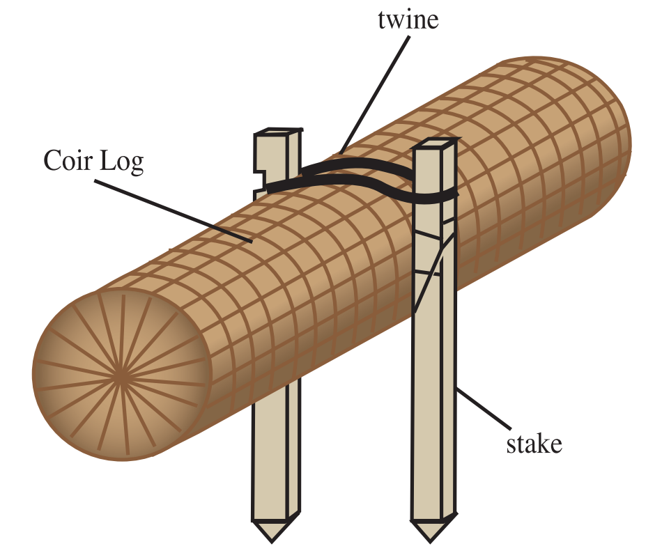
| + | [[Media:Screenshot 2025-11-19 111153.png|Coir log with stakes (Terrafix Geosynthetics, 2015)<ref>Terrafix Geosynthetics. 2015. Coir Mats and Logs. https://terrafixgeo.com/wp-content/uploads/2021/03/CoirMatsLogsBrochure-2015.pdf</ref>]] | ||
| | | | ||
[[File:Screenshot 2025-08-06 101657.png|200px|frameless|center]] | [[File:Screenshot 2025-08-06 101657.png|200px|frameless|center]] | ||
| Line 251: | Line 267: | ||
*Do not use in natural features | *Do not use in natural features | ||
| | | | ||
| + | [[Media:Rock_check_dams_diagram.pdf|Temporary rock flow check dam diagram]] | ||
| | | | ||
[[File:Screenshot 2025-08-06 100905.png|200px|frameless|center]] | [[File:Screenshot 2025-08-06 100905.png|200px|frameless|center]] | ||
| Line 267: | Line 284: | ||
*required by municipality | *required by municipality | ||
| | | | ||
| + | [[Media:Mud mat.pdf|Mud mat]] | ||
| | | | ||
[[File:Screenshot 2025-07-30 161438.png|200px|frameless|center]] | [[File:Screenshot 2025-07-30 161438.png|200px|frameless|center]] | ||
| Line 278: | Line 296: | ||
*best used in treatment train | *best used in treatment train | ||
| | | | ||
| + | [[Media:B2_SEDIMENT_DEWATERING_BAG_unfrozen.pdf|Dewatering treatment train (unfrozen)]] | ||
| + | |||
| + | [[Media:B2_SEDIMENT_DEWATERING_BAG_(frozen.pdf|Dewatering treatment train (frozen)]] | ||
| | | | ||
[[File:Screenshot 2025-08-06 103437.png|200px|frameless|center]] | [[File:Screenshot 2025-08-06 103437.png|200px|frameless|center]] | ||
| Line 289: | Line 310: | ||
*treatment train required for drainage areas >1 ha | *treatment train required for drainage areas >1 ha | ||
| | | | ||
| + | [[Media:Excavated drop inlet.pdf|Excavated drop inlet]] | ||
| + | [[Media:Gravel jacket.pdf|Gravel jacket]] | ||
| | | | ||
[[File:Screenshot 2025-08-06 103724.png|200px|frameless|center]] | [[File:Screenshot 2025-08-06 103724.png|200px|frameless|center]] | ||
| Line 300: | Line 323: | ||
*drainage areas ≤ 2 ha that do not drain to another detention feature | *drainage areas ≤ 2 ha that do not drain to another detention feature | ||
| | | | ||
| + | [[Media:Ediment trap within an earthen ditch.pdf|Sediment trap within an earthen ditch]] | ||
| | | | ||
[[File:Screenshot 2025-11-13 103532.png|200px|frameless|center]] | [[File:Screenshot 2025-11-13 103532.png|200px|frameless|center]] | ||
| Line 309: | Line 333: | ||
*Treatment of runoff from drainage areas > 2 ha | *Treatment of runoff from drainage areas > 2 ha | ||
*end-of-pipe control | *end-of-pipe control | ||
| − | | [https://sustainabletechnologies.ca/home/erosion-and-sediment-control/construction-sediment-control-ponds/ STEP Wet Ponds Page] | + | | |
| + | [[Media:B2_SEDIMENT_CONTROL_PONDS_diagram.pdf|Sediment control pond]] | ||
| + | |||
| + | [https://sustainabletechnologies.ca/home/erosion-and-sediment-control/construction-sediment-control-ponds/ STEP Wet Ponds Page] | ||
| | | | ||
[[File:Screenshot 2025-08-06 104639.png|200px|frameless|center]] | [[File:Screenshot 2025-08-06 104639.png|200px|frameless|center]] | ||
| Line 359: | Line 386: | ||
<div style="float: right; padding-left: 20px; padding-bottom: 10px;"> | <div style="float: right; padding-left: 20px; padding-bottom: 10px;"> | ||
| − | <pdf width=" | + | <pdf width="400" height="600">File:Sample-Spill-Response-Plan.pdf</pdf> |
</div> | </div> | ||
| − | Creating a spill response, control, and reporting plan is a key part of | + | Creating a spill response, control, and reporting plan is a key part of ESC for construction projects. Although spills are not common, their environmental impact can be significant. A well-developed plan allows for quick, effective action that reduces environmental harm and cleanup needs. It also shows due diligence in protecting natural features. |
{{textbox|At a minimum, the plan should include: | {{textbox|At a minimum, the plan should include: | ||
| Line 380: | Line 407: | ||
==Plan submission and approval== | ==Plan submission and approval== | ||
| + | [[File:Screenshot 2025-11-13 142811.png|428px|thumb|right|Flow chart showing the ESC plan approval process, divided into early, intermediate, and late stages.]] | ||
The submission requirements for erosion and sediment control strategies are organized based on three planning stages: early, intermediate, and late, which align with both the land-use and infrastructure planning processes. Each stage builds on the previous one, helping to gradually refine ESC strategies as more project details become available. | The submission requirements for erosion and sediment control strategies are organized based on three planning stages: early, intermediate, and late, which align with both the land-use and infrastructure planning processes. Each stage builds on the previous one, helping to gradually refine ESC strategies as more project details become available. | ||
{{textbox|*In the early stage, the focus is on high-level planning, identifying potential impacts, and committing to appropriate ESC approaches. | {{textbox|*In the early stage, the focus is on high-level planning, identifying potential impacts, and committing to appropriate ESC approaches. | ||
| Line 385: | Line 413: | ||
*In the late stage, a comprehensive ESC report and drawings are submitted.}} | *In the late stage, a comprehensive ESC report and drawings are submitted.}} | ||
| − | This progressive approach ensures that ESC strategies evolve alongside the project’s design and that regulatory requirements are addressed at each stage. The permits and approvals required for an urban construction project are dictated by relevant legislation as well as project and site-specific circumstances. Early consultation with regulatory agencies is encouraged in order to allow time for any necessary permits and approvals to be issued. Refer to Chapters 8 and 9 in the 2019 | + | This progressive approach ensures that ESC strategies evolve alongside the project’s design and that regulatory requirements are addressed at each stage. The permits and approvals required for an urban construction project are dictated by relevant legislation as well as project and site-specific circumstances. Early consultation with regulatory agencies is encouraged in order to allow time for any necessary permits and approvals to be issued. Refer to Chapters 8 and 9 in the [http://sustainabletechnologies.ca/app/uploads/2020/01/ESC-Guide-for-Urban-Construction_FINAL.pdf Erosion and Sediment Control Guide for Urban Construction] (2019) for full details on requirements for each planning stage and the approvals process. |
For projects requiring a TRCA permit, information on the TRCA permitting process can be found [https://trca.ca/planning-permits/how-the-permit-process-works/ here]. | For projects requiring a TRCA permit, information on the TRCA permitting process can be found [https://trca.ca/planning-permits/how-the-permit-process-works/ here]. | ||
| Line 392: | Line 420: | ||
==Routine inspection== | ==Routine inspection== | ||
| + | <div style="overflow: hidden;"> | ||
| + | |||
| + | <div style="float: right; padding-left: 20px; padding-bottom: 10px;"> | ||
| + | <pdf width="400" height="600">File:Inpsection_ESC-Guide-for-Urban-Construction_FINAL.pdf</pdf> | ||
| + | </div> | ||
| + | |||
ESC inspection programs regularly assess the effectiveness of BMPs, identify maintenance and repair needs, and identify areas where BMPs should be replaced or augmented. Consult the appendices linked in the first column of table 1 and 2 for BMP-specific inspection points. | ESC inspection programs regularly assess the effectiveness of BMPs, identify maintenance and repair needs, and identify areas where BMPs should be replaced or augmented. Consult the appendices linked in the first column of table 1 and 2 for BMP-specific inspection points. | ||
| Line 398: | Line 432: | ||
*During the initial installation of ESC measures | *During the initial installation of ESC measures | ||
*On a weekly basis during active construction | *On a weekly basis during active construction | ||
| − | *Before and after significant rainfall and snowmelt events | + | *Before and after significant [[Understanding rainfall statistics|rainfall]] and [[Winter|snowmelt]] events |
*After any extreme weather which could result in damage to ESC measures | *After any extreme weather which could result in damage to ESC measures | ||
*Daily during extended rain or snowmelt periods | *Daily during extended rain or snowmelt periods | ||
| Line 404: | Line 438: | ||
*During or immediately following any spill event | *During or immediately following any spill event | ||
*Before construction is shut down for the winter to ensure the site is ready for freezing conditions and thaws | *Before construction is shut down for the winter to ensure the site is ready for freezing conditions and thaws | ||
| − | *At the end of construction to confirm that the site has achieved at least 80% stabilization | + | *At the end of construction to confirm that the site has achieved at least 80% stabilization and that permanent vegetation areas are well-established and effectively preventing erosion}} |
| − | + | <div style="display:flex; justify-content:center; gap:20px; flex-wrap:wrap;"> | |
| + | <div style="flex:1; min-width:400px; text-align:center;"> | ||
| + | [[File:ESC ponding 2.png|400px|center|thumb|Ponding in front of this catchbasin indicates that this ESC inlet control is working. Ponding water allows for suspended sediments to settle. (Photo source: CISEC)]] | ||
| + | </div> | ||
| − | + | <div style="flex:1; min-width:400px; text-align:center;"> | |
| − | [[File:ESC ponding 1.png| | + | [[File:ESC ponding 1.png|400px|center|thumb|This inlet control has worked well, but the sediment should be removed as soon as possible. (Photo source: CISEC)]] |
| + | </div> | ||
| + | </div> | ||
| + | |||
| + | Where applicable, inspections of ESC measures should be integrated with inspections of LID features. [[Inspections_and_maintenance#Inspection_.26_Maintenance_Terminology|Construction and assumption inspections]] for LID features are often required on the same schedule as ESC measures - for example, weekly, after major storm events, or at key construction milestones. You can download (downward facing arrow on the top righthand side) and print (printer emoticon on top right hand side) the inspection report template on the right. | ||
==Performance Monitoring== | ==Performance Monitoring== | ||
| + | [[File:Screenshot 2025-11-05 155529.png|400px|thumb|right|Map showing an example construction site with two pond discharges and an upstream and downstream monitoring site.]] | ||
[[File:Screenshot 2025-11-05 155737.png|300px|thumb|right|An in-water turbidity monitoring station.]] | [[File:Screenshot 2025-11-05 155737.png|300px|thumb|right|An in-water turbidity monitoring station.]] | ||
| Line 448: | Line 490: | ||
|} | |} | ||
| − | The extent of turbidity monitoring and methods used on a given construction project should be based on erosion risk, receiving water flows, presence of species at risk, and type and location of discharge points. The monitoring program for sites applying the receiving water target should include the following components: | + | The extent of turbidity [[monitoring]] and methods used on a given construction project should be based on [[Erosion#Erosion_potential|erosion risk]], receiving water flows, presence of species at risk, and type and location of discharge points. |
| + | {{textbox|The monitoring program for sites applying the receiving water target should include the following components: | ||
*One continuous online turbidity monitoring station 5 to 15 m downstream of the last site discharge point. | *One continuous online turbidity monitoring station 5 to 15 m downstream of the last site discharge point. | ||
| − | *At least one continuous online turbidity monitoring station immediately upstream of the site. | + | *At least one continuous online turbidity monitoring station immediately upstream of the site.}} |
| − | + | Each turbidity monitoring station should be equipped with a turbidity sonde, data logger, power supply, protective enclosure, and, where Species at Risk (SAR) are present, telemetry capabilities. Continuous turbidity monitoring should be maintained until the site has reached at least 80% effective permanent stabilization. Where continuous monitoring is not feasible, grab samples should be collected. To support interpretation of turbidity exceedances, [[Intensity-Duration-Frequency Curves|precipitation]] data should be obtained from a rain gauge located within 5 km of the site. Clear protocols for responding to and reporting turbidity exceedances should be established for all sites with continuous monitoring. | |
| − | |||
| − | Each turbidity monitoring station should be equipped with a turbidity sonde, data logger, power supply, protective enclosure, and, where Species at Risk (SAR) are present, telemetry capabilities. Continuous turbidity monitoring should be maintained until the site has reached at least 80% effective permanent stabilization. Where continuous monitoring is not feasible, grab samples should be collected. To support interpretation of turbidity exceedances, precipitation data should be obtained from a rain gauge located within 5 km of the site. Clear protocols for responding to and reporting turbidity exceedances should be established for all sites with continuous monitoring. | ||
==Maintenance of ESC== | ==Maintenance of ESC== | ||
| Line 543: | Line 584: | ||
==Additional Resources== | ==Additional Resources== | ||
*[https://www.beyond21.world/sustainable-infrastructure-lid Course on Introduction to Erosion and Sediment Control & Best Practices for LID Implementation] | *[https://www.beyond21.world/sustainable-infrastructure-lid Course on Introduction to Erosion and Sediment Control & Best Practices for LID Implementation] | ||
| − | *[https://sustainabletechnologies.ca/erosion-and-sediment-control-guide-for-urban-construction/ ESC guide for urban construction workshop (To access, enter password ESCGUCwebinar20] | + | *[https://sustainabletechnologies.ca/erosion-and-sediment-control-guide-for-urban-construction/ ESC guide for urban construction workshop (To access, enter password ESCGUCwebinar20)] |
*[https://sustainabletechnologies.ca/introduction-to-erosion-sediment-control-e-learning-course/ Introduction to Erosion Sediment Control E-Learning Course] | *[https://sustainabletechnologies.ca/introduction-to-erosion-sediment-control-e-learning-course/ Introduction to Erosion Sediment Control E-Learning Course] | ||
*[https://sourcetostream.com/2023-track-2-day-2-dhanraj/ Erosion Control Infrastructure – Asset Operation and Management Plans Presentation] | *[https://sourcetostream.com/2023-track-2-day-2-dhanraj/ Erosion Control Infrastructure – Asset Operation and Management Plans Presentation] | ||
*[https://prod-environmental-registry.s3.amazonaws.com/2022-01/Draft%20LID%20Stormwater%20Management%20Guidance%20Manual%202022.pdf Low Impact Development Stormwater Management Guidance Manual (2022) Chapter 7: Erosion and Sediment Control during Construction] | *[https://prod-environmental-registry.s3.amazonaws.com/2022-01/Draft%20LID%20Stormwater%20Management%20Guidance%20Manual%202022.pdf Low Impact Development Stormwater Management Guidance Manual (2022) Chapter 7: Erosion and Sediment Control during Construction] | ||
| − | |||
*[https://www.ontario.ca/page/b-6-guidelines-evaluating-construction-activities-impacting-water-resources B-6 Guidelines for Evaluating Construction Activities Impacting on Water Resources (Government of Ontario)] | *[https://www.ontario.ca/page/b-6-guidelines-evaluating-construction-activities-impacting-water-resources B-6 Guidelines for Evaluating Construction Activities Impacting on Water Resources (Government of Ontario)] | ||
*[https://sustainabletechnologies.ca/app/uploads/2018/01/V6-2014-NON-Ontario-CISEC-Manual_NEW.pdf Certified Inspector of Sediment and Erosion Control Training Manual (2014) CISEC ] | *[https://sustainabletechnologies.ca/app/uploads/2018/01/V6-2014-NON-Ontario-CISEC-Manual_NEW.pdf Certified Inspector of Sediment and Erosion Control Training Manual (2014) CISEC ] | ||
| − | *[https://sustainabletechnologies.ca/app/uploads/2020/04/Terrafix-summit-2020.pdf | + | *[https://sustainabletechnologies.ca/app/uploads/2020/04/Terrafix-summit-2020.pdf Presentation on the Erosion and Sediment Control Guide for Urban Construction (2019)] |
*[https://sustainabletechnologies.ca/home/erosion-and-sediment-control/construction-sediment-control-ponds/erosion-and-sediment-control-practices-evaluation-vaughan-ontario/ Erosion and Sediment Control Practices Evaluation – Vaughan, Ontario] | *[https://sustainabletechnologies.ca/home/erosion-and-sediment-control/construction-sediment-control-ponds/erosion-and-sediment-control-practices-evaluation-vaughan-ontario/ Erosion and Sediment Control Practices Evaluation – Vaughan, Ontario] | ||
*[https://www.csagroup.org/store/product/2426297/ CAN/CSA-W202-18: Erosion and sediment control inspection and monitoring ] | *[https://www.csagroup.org/store/product/2426297/ CAN/CSA-W202-18: Erosion and sediment control inspection and monitoring ] | ||
Latest revision as of 16:49, 19 November 2025
Overview[edit]

Erosion and sediment controls (ESC) are technologies, practices and procedures that are applied to prevent the release of sediment from construction sites. Rapid urban expansion and associated construction activities are a significant source of stress to the natural environment. As construction processes involve the removal of vegetation and de-stabilization of soils, they can accelerate natural processes of erosion and sedimentation, mobilizing more sediment and associated contaminants that can ultimately end up in downstream receiving water systems. ESC measures are essential to help reduce these sediment loads from active construction sites and protect downstream aquatic habitats from becoming impaired.
Inadequate ESC during construction can cause:
- sediment-laden runoff to enter downstream and adjacent natural features, including streams, lakes, wetlands and woodlots;
- deposition of sediment on adjacent private property and roadways;
- clogging of onsite stormwater management systems and LIDs;
- expensive cleanup and restoration costs;
- delays or stop-work orders; and
- fines from regulatory agencies.
Implementing effective ESC practices throughout all stages of construction is essential to sustainable urban growth and ensuring regulatory compliance.
Erosion risk assessments (ERA)[edit]
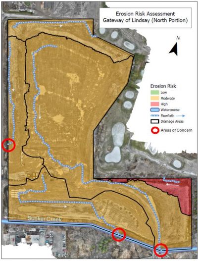
To manage the potential negative impacts of construction activities in the absence of effective ESC measures, Erosion Risk Assessments (ERAs) are conducted to guide the selection and placement of appropriate ESC practices on site.
ERAs are recommended when:
- the extent of land disturbance is greater than 10 ha and duration is longer than 30 days, or
- construction activities are planned in or near natural water features, or
- the site drains to species at risk habitat
The hybrid qualitative ERA approach is recommended in the above situations, except where local regulatory agencies require a different approach. The hybrid qualitative ERA approach estimates erosion risk by dividing a site into areas based on soil, slope, and ground cover, then rating each area as low, moderate, or high erosion risk to help choose the right erosion control practices for each stage of construction. Completing an ERA demonstrates due diligence, identifies high-risk areas early, informs effective BMP selection and placement, guides the use of enhanced controls, and provides context for decision-making. To learn more about ERAs, read section 6.2 in the Erosion and Sediment Control Guide for Urban Construction (2019).
ESC plan design[edit]

An ESC plan should be created based on a given site’s ERA, with more controls used in the higher risk areas.
An ESC plan should be designed for each stage of construction:
- Topsoil stripping, grading, and stabilization
- Servicing
- Building construction
- Final stabilization/rehabilitation and ESC decommissioning
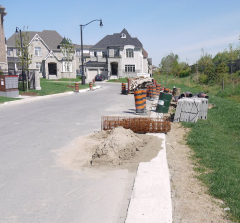
An ESC plan should include drawings, standard notes and reports depicting and describing the site conditions (e.g. grades, locations of natural features, soil stockpiles and other key points of interest) during each phase of construction, and the BMPs that will be applied to mitigate erosion and sediment transport.
Types of ESC[edit]
Erosion controls
• prevent exposed soils from being entrained by water or wind
• address sediment at its source
Sediment controls
• remove sediment suspended in stormwater through settling and filtration
The most effective application of ESC utilizes a multi-barrier approach, in which erosion controls and sediment controls are installed in sequence to form a resilient system that protects the natural environment from sediment-related impacts. A multi-barrier system incorporates built-in redundancy, ensuring that if one control fails, additional measures remain in place to safeguard downstream features. Selecting appropriate BMPs for each project stage requires an understanding of their function, intended use, expected performance, and maintenance needs. Note: Isolation measures are not covered on this page but are detailed in the 2019 Erosion and Sediment Control Guide for Urban Construction.
Table 1 and 2 provide an overview of common erosion and sediment controls. Click on the BMP name in the first column to read the detailed design requirements and installation, inspection, maintenance, and decommissioning guidance from the 2019 Erosion and Sediment Control Guide for Urban Construction. A description and common applications of each practice are listed in the second and third columns, respectively. The fourth column provides additional resources and the fifth column shows an example image of the BMP.
Good and poor examples of ESC installation are shown on the right side. Additional examples can be found on the pre-construction wiki.
Erosion controls[edit]


| BMP (click for more information) | Description | Applicability | Drawings and Additional Resources | Example Image |
|---|---|---|---|---|
| Minimized or Phased Land Clearing | Preservation of vegetated areas intercepts and infiltrates rainfall. | Areas not being immediately developed on larger sites (>10 ha) |
 | |
| Vegetated Filter Strips | Gently sloping, vegetated areas that slow and filter runoff. | Areas that may benefit from leaving vegetation in place | Vegetated filter strip design Wiki |  |
| Slope Drains | Flexible pipe that conveys water down a disturbed slope to prevent erosion from concentrated runoff. | Exposed (and especially long or steep) slopes that convey concentrated flow |
 | |
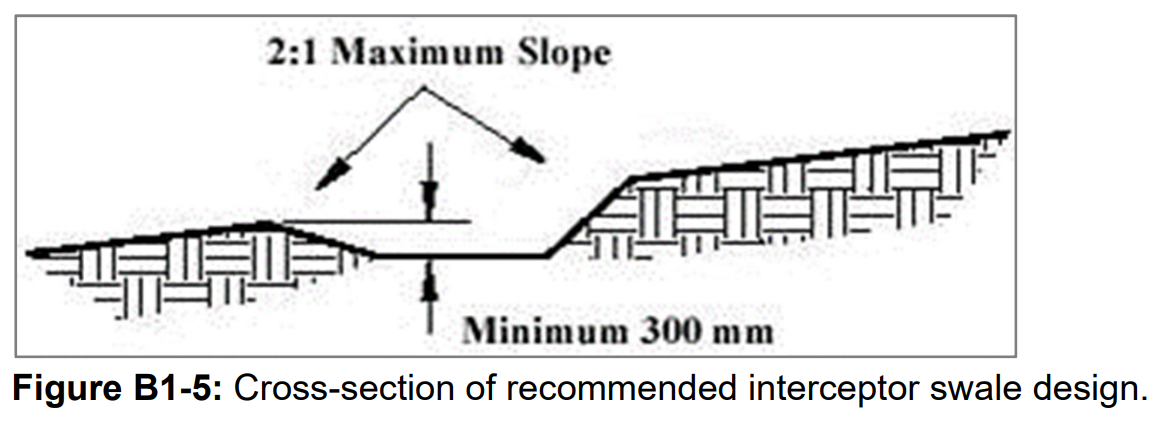
| Interceptor Swales | Stabilized flow path that conveys runoff away from bare soil to sediment control measures. | Any unstabilized areas, but especially where:
|
 | |
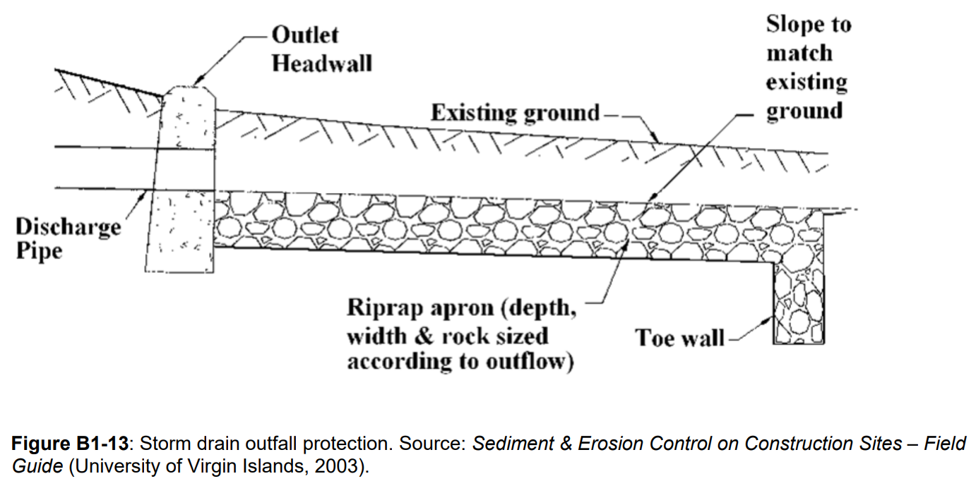
| Outlet Protection | Energy dissipation devices or surface hardening that prevents scour erosion at outlets. | Base of any outlet releasing concentrated flow |
 | |
| Mulching | Layer of organic material (e.g., straw, bark, wood shavings, paper fibre, compost) that absorbs rainfall and acts as a physical barrier to erosion. |
|
 | |
| Seeding | Application of seed to establish vegetation for soil stability. |
 Click to expand. |
 | |
| Surface Roughening | Creates uneven surfaces and depressions to reduce runoff velocity, trap sediment, keep seed in place, and improve vegetation establishment |
|
Surface roughening diagram for slopes steeper than 3H:1V and H > 1.5 m Surface roughening for slopes steeper than 2H:1V using bulldozer (Virginia Department of Environmental Quality)[3] |
 |
| Rolled Erosion Control Products | Netting, blankets, or turf reinforcement mats act as a physical barrier to erosion. Biodegradable options free of plastic netting prevent wildlife ensnaring. |
|
 | |
| Chemical Soil Stabilization | Substances that bind soil particles to stabilize the soil surface. |
|
Anionic Polyacrylamide Application Guide for Urban Construction in Ontario (TRCA, 2013) |
 |
Sediment controls[edit]


| BMP (click for more information) | Description | Applicability | Drawings and Additional Resources | Example Image |
|---|---|---|---|---|
| Sediment Control Fence | Geotextile material supported by posts and trenched into the ground to support settling of sheet flows. |
|
 | |
| Filter Socks | Tubular mesh socks filled with wood chip or compost that dissipate flow velocities and pond water to promote sediment settling. |
|
S2S Conference Presentation |
 |
| Natural Fibre Logs | Similar to filter socks but made of biodegradable materials such as coir, straw, or wood. |
|
 | |
| Rock Check Dams | Weir constructed across channels from granular material and geotextile to reduce flow velocity. |
|
 | |
| Vehicle Tracking Controls | Measures such as mud mats, shaker racks, or wheel washers to prevent vehicles from tracking mud offsite. |
Vehicle tracking controls:
Wheel washing:
|
 | |
| Sediment Dewatering Bags | Large geotextile bags used to filter sediment-laden water from pumped discharge. |
|
 | |
| Storm Drain Inlet Protection | Blocks sediment entry to inlets while allowing water through. |
|
 | |
| Sediment Traps | Runoff detention area created by an embankment or depression to allow sediment settling. |
|
 | |
| Sediment Ponds | Similar to sediment traps but larger. Excavated depression for permanent water retention. |
|
 | |
| Weir Tanks | Tanks that detain stormwater runoff to promote sediment settling. |
|
 | |
| Polymer Flocculants | Chemical agents that bind suspended particles to enhance sediment removal. |
|
STEP polymers page |
 |
| Active Treatment Systems | Systems combining tanks, flocculants, and filters for precise and high-efficiency contaminant removal. |
|
 |
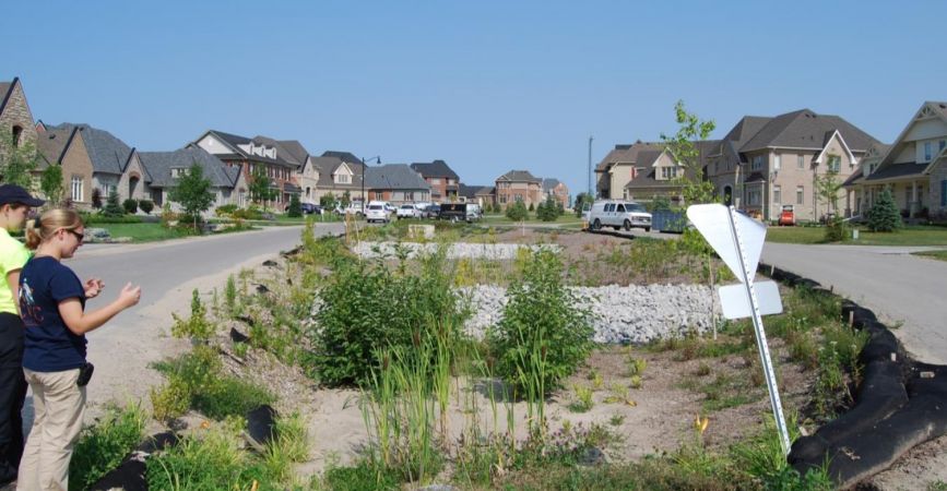
Protecting LID features during construction[edit]
LID practices that promote infiltration as their primary function for water quality & management of overland flows, such as bioretention areas, permeable pavements, and infiltration trenches, are vulnerable to damage during construction activities that can compromise their ability to function as intended. These features can become clogged with sediment, experience erosion at inlets and in planted areas, suffer compaction from heavy machinery, or be contaminated by pollutants in construction runoff. To minimize these risks and maintain effective protection throughout all phases of construction, the following best practices should be implemented:
Keep LID perimeter controls in working order throughout construction. ESC measures at this bioretention feature were removed before construction in its drainage was complete, allowing sediment into it (Photo Source: CVC).
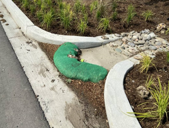
Protect LID inlets.
Avoid heavy equipment on infiltration areas (i.e., driving vehicles through filter beds, or over granular water storage and bedding layers). Identify and mark LID areas to increase awareness.
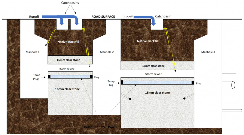
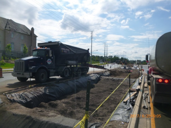
Phase construction so that LID measures are constructed last. Underground LID features can be built early in the construction process, provided they are protected by a barrier such as a plug. Graphic shows an exfiltration system with a temporary plug keeping construction runoff out of the exfiltration area.
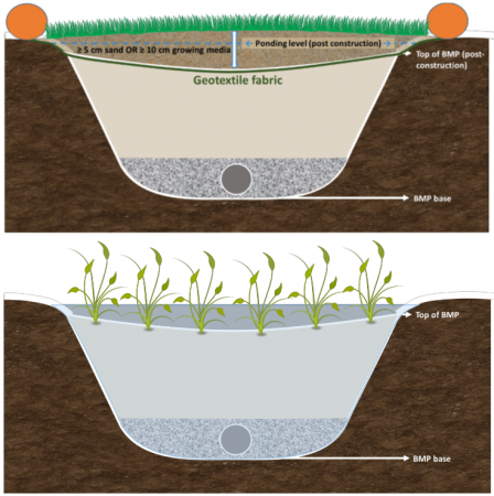
Keep LID installations offline via flow diversion until construction is complete, the drainage area is stabilized, and vehicle mud tracking is stopped. Image shows a bioretention feature during construction (left) and post-construction (right). The LID feature is protected using geotextile fabric, a sacrificial layer of stabilized sand/growing media with vegetation, and a filter sock. Once surrounding construction is complete, the layer of growing media is removed and the BMP starts receiving flow.
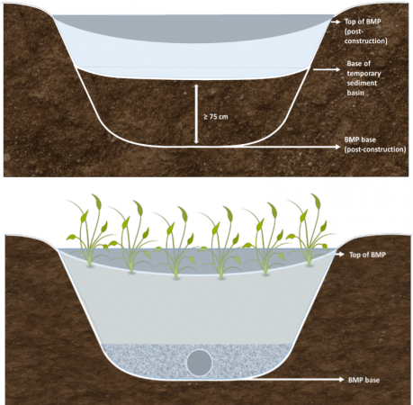
Avoid using LID areas as temporary detention basins, but in cases where flow cannot be routed around LID areas, protection should be used to prevent accumulated sediment from migrating into the subgrade. Graphic shows a bioretention feature during construction (left) and post-construction (right). At least 75 cm of native soil is retained between the base of the detention basin and the base of the LID feature, so that sediment accumulation in the detention basin can be removed. Once it is excavated and filled, ESC measures should be put in place to protect it until all drainage area construction and stabilization are complete.
Be mindful of stockpile locations relative to LID areas.
Inspect LID areas during ESC site inspections.


