Difference between revisions of "Bioretention: Sizing"
Jenny Hill (talk | contribs) m |
Jenny Hill (talk | contribs) m (Jenny Hill moved page Bioretention: Sizing for depth to Bioretention: Sizing without leaving a redirect) |
(No difference)
| |
Revision as of 23:26, 9 November 2017
To size a bioretention facility using this page, the design infiltration rate (q' in mm/hr, after correction) of the native underlying soils must estimated, and the maximum available excavation depth (d in m) is the primary constraint to sizing.
If the space on the ground is the tighter constraint to design, try this article on sizing bioretention for space.
<iframe src="https://docs.google.com/spreadsheets/d/e/2PACX-1vQGMHASguRdALH5nOF3AZeox9vFCJh9PMtj8nG-rmB4NMqtWinbimGirn1dfcUzeJm02LWfYjx0QXB6/pubhtml?gid=172024974&single=true&widget=true&headers=false"></iframe>
Step 1, total volume[edit]
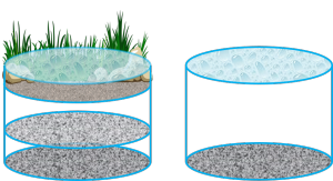
The bioretention facility will comprise three vertical zones:
- a 'bowl' permitting water to pond occasionally (maximum depth, dp = 0.5 m)
- a layer of filter media to support plant growth (minimum depth, dm = 0.6 m) , and
- a reservoir of stone to store and facilitate infiltration of additional water (depth, dR, includes 0.1 m choking layer).
Firstly, all three zones will be sized together within the limited depth to estimate the footprint area of the whole bioretention facility. To do this the mean void ratio (VR) will estimated as ~ 0.4.
To calculate the required practice area (Ap) or footprint where the depth is constrained:
Where:
- V = Required volume of storage in m3
- VR = Void ratio (porosity), as measured (or default to 0.4)
- Ap = Area of the infiltration practice in m2
- dT = Total depth of infiltration practice in m (= db + dm + dR)
Step 1 alternative, accounts for infiltration during a design storm event[edit]
This may be desirable where the practice is located on particularly freely draining soils and/or where the design storm is of longer duration. To calculate the required practice area (Ap) or footprint where the depth is constrained:
Where:
- D = Duration of design storm in hrs
- i = Intensity of design storm in mm/hr
- f' = Design infiltration rate in mm/hr
- VR = Void ratio (porosity), as measured (or default to 0.35 for all aggregates)
- Ap = Area of the infiltration practice in m2
- Ac = Area of the catchment in m2
- dT = Total depth of infiltration practice in m (= db + dm + dR)
Step 2, geometry and perimeter[edit]
Fit the bioretention facility into the site plan. It is necessary to have an idea of the perimeter of the facility.
Narrow, linear cells drain faster than round or blocky footprint geometries.
Divide the area of the practice (Ap) by the perimeter (P).
Step 3, depth of bowl,db[edit]
The 'bowl' area is simply the depressed elevation of the surface compared to the surrounding areas; a space to permit temporary ponding.
The depth of the bowl would not typically exceed 0.5 m due to safety concerns.
Some jurisdictions or particular sites may demand a lower maximum depth of ponding. It is worth bearing in mind that in most cases this ponded water will only occur once or twice per year.
The ponded water within the bowl should drain within 48 hrs. This addresses public concerns about mosquitoes and reduces the probability of losing vegetation due to saturated growing conditions.
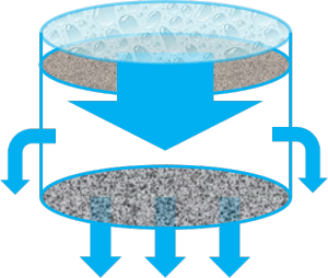
The drainage of the bowl is not usually constrained by the surface infiltration (filter media should drain > 25 mm/hr). The infiltration of water from the bowl is determined by the drainage of the filter media and reservoir into the soils.
To estimate the time (t) to fully drain the facility:
Final step[edit]
Check the mounding of groundwater beneath the facility to ensure no incompatibility with nearby sensitive receptors.
Note that some adaptations have been made to this tool, from the original hosted by the USGS.


![{\displaystyle t={\frac {V_{R}A_{p}}{f'P}}ln\left[{\frac {\left(d+{\frac {A_{p}}{P}}\right)}{\left({\frac {A_{p}}{P}}\right)}}\right]}](https://wikimedia.org/api/rest_v1/media/math/render/svg/a9776616060d3374e3f396538eb88735772689c5)