Uncategorized files
Jump to navigation
Jump to search
Showing below up to 235 results in range #1,001 to #1,235.
View (previous 500 | next 500) (20 | 50 | 100 | 250 | 500)
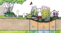
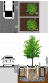
 STEP Minto Cistern P1 - Copy.jpg 1,495 × 981; 284 KB
 STEP cropped.jpg 586 × 412; 132 KB
 STEP logo.png 656 × 149; 39 KB
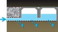
 SWM Arches.jpg 841 × 473; 50 KB
 SWM Crates.jpg 840 × 473; 41 KB
 SWM Pipe.jpg 841 × 473; 52 KB
 SWM Vaults.jpg 841 × 473; 39 KB
 SWM problems.PNG 1,013 × 439; 597 KB
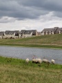 SWM sheep.jpg 3,456 × 4,608; 1.67 MB
 SWPSouthernON EN.pdf ; 608 KB
 SWTT High Perm Soil Cells Final.png 2,079 × 3,741; 7.89 MB
 SWTT Low Perm Soil Cells Final.png 2,064 × 3,741; 7.9 MB
 SWTT Struct Pan High Perm Final.png 2,333 × 3,696; 6.89 MB
 SWTT Struct Pan High Perm Final crop.png 2,059 × 3,696; 5.6 MB
 SWTT Struct Soil Med High Perm Final.png 2,053 × 3,741; 7.65 MB
 Salt comparison.PNG 701 × 858; 197 KB
 Salt mgmnt.PNG 1,011 × 516; 614 KB
 Salt mgmnt guidelines.PNG 1,011 × 516; 981 KB
 Salt mgmnt parkign lots.PNG 1,007 × 357; 482 KB
 Sand vs salt.PNG 1,006 × 365; 433 KB
 Sandy Bioretention Soil Mix.jpg 2,448 × 3,264; 2 MB
 Scarification.jpg 4,032 × 3,024; 7.46 MB
 Scirpus atrovirens.jpeg 1,024 × 683; 359 KB
 Scirpus cyperinus jheiser.jpg 1,024 × 859; 360 KB
 Scour-fabric.jpg 242 × 209; 12 KB
 Screeningprocessdiagram.png 962 × 1,257; 44 KB
 Secch idisk.PNG 611 × 504; 338 KB
- Section 4 Handouts.pdf ; 12.19 MB
 Sections perimeters.png 814 × 528; 15 KB
 Sediment accumulation perm.JPG 629 × 538; 79 KB
 Sediment pad.JPG 690 × 433; 66 KB
 Sediment pad Toronto.JPG 4,032 × 3,024; 8.76 MB
 Sediment removal.PNG 846 × 517; 913 KB
 Shade ball coverage esker.PNG 1,360 × 821; 2.5 MB
 Shade balls brampton.jpg 1,430 × 1,073; 286 KB
 Shade balls close up.jpg 687 × 515; 55 KB
 Shallow monitoring well.png 3,017 × 2,277; 5.02 MB
 Shallow monitoring well update.png 904 × 692; 627 KB
 Shutterstock 94975348+resized.jpg 350 × 232; 51 KB
 Side oats.jpg 2,500 × 1,667; 234 KB
 Simon Bunn.PNG 1,072 × 1,013; 2 MB
 Simulated storm event.PNG 781 × 578; 1.14 MB
 Simulated storm event in a swale.PNG 556 × 370; 638 KB
 Single ring infilt p.p.PNG 631 × 754; 1.17 MB
 Site Conditions ROW.jpg 1,024 × 768; 877 KB
 Site Conditions ROW2.jpg 1,024 × 768; 905 KB
 Site Conditions Road Right of Way Cover.jpg 1,024 × 768; 746 KB
 Site design.png 1,003 × 378; 718 KB
 Sizing Bioretention.jpg 1,277 × 1,025; 190 KB
 Sizing bio1.png 919 × 499; 408 KB
 Sizing bio2.png 530 × 449; 177 KB
 Sizing calculator.PNG 1,141 × 215; 18 KB
 Sizing flow-through planter.jpg 1,341 × 1,030; 171 KB
 Slope Fail swale.PNG 582 × 386; 644 KB
 Slope Pass swale.PNG 570 × 379; 628 KB
 Small Commercial Sites Options.png 1,056 × 595; 453 KB
 Smart about salt training.PNG 407 × 412; 229 KB
 Smart drain.jpg 2,448 × 2,068; 671 KB
 Sneezeweed.jpg 180 × 200; 40 KB
 Snow filter strip.png 393 × 260; 272 KB
 Snow piles.jpg 4,608 × 3,456; 2.11 MB
 Soakaway monitorign well.PNG 414 × 583; 762 KB
 Soakaways infiltration et.al.png 1,652 × 373; 1.17 MB
 Soil Cell Plan View.PNG 1,300 × 832; 221 KB
 Soil Cell Profile View.PNG 1,006 × 449; 145 KB
 Soil bulk density figure 8.7.PNG 1,057 × 805; 576 KB
 Soil cells - construction.PNG 857 × 420; 1.08 MB
 Soil moisture zones levels.PNG 1,465 × 802; 2.32 MB
 Soil testing indicators.PNG 867 × 443; 194 KB
 Solid splashpad.jpg 1,000 × 664; 395 KB
 Sorptive media.jpg 4,608 × 3,456; 2.67 MB
 Source Jennifer Rosales tree bumpout.jpg 700 × 522; 124 KB
 Source Protection Atlas tool.PNG 1,363 × 910; 1.62 MB
 Source Protection regions map.PNG 1,128 × 857; 418 KB
 Sources of nitrogen.PNG 897 × 530; 792 KB
 Spill containgment site - pre construction - Mississauga.JPG 2,816 × 2,112; 1.46 MB
 Spill containment structure - Mississauga.JPG 2,816 × 2,112; 1.48 MB
 Sporobolus-cryptandrus-in-ahaines-a.jpg 912 × 1,000; 179 KB
 Sporobolus michauxianus.jpeg 500 × 375; 199 KB
 Spot8 p2 20190820.jpg 4,032 × 3,024; 5.02 MB
 Spotted joepye.jpg 244 × 220; 24 KB
 Spray-Irrigation.jpg 800 × 571; 209 KB
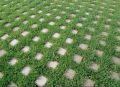
 Square Grid.png 271 × 241; 2 KB
 St-patricks-parade-8-1024.jpg 550 × 550; 133 KB
 Staff testing.PNG 808 × 551; 1.34 MB
 Stepped cells.png 1,229 × 884; 635 KB
 Steps 1 & 2.PNG 1,895 × 863; 1.57 MB
 Steps 3 & 4.PNG 1,894 × 903; 1.54 MB
 Steps 5 & 6.PNG 1,895 × 850; 1.36 MB
 Stockpile in gutter.jpg 4,032 × 3,024; 3.97 MB
 Stone in ponding zone.jpg 1,024 × 768; 390 KB
 Storage TTT.png 177 × 78; 5 KB
 Storm bmps rev3.png 502 × 447; 226 KB
 Storm drain protection.PNG 506 × 289; 377 KB
 Stormwater Planter Updated.png 2,043 × 3,098; 5.12 MB
 Stormwater Planter Updated compacted.png 2,055 × 3,277; 5.96 MB
 Stormwater Tree Trench Structural Panel Soil Cell.png 2,109 × 3,508; 7.7 MB
 Stormwater Tree Trench high permeability native subsoil with soil cells.png 2,006 × 3,444; 7.97 MB
 Stormwater Tree Trench high permeability native subsoil with structural soil medium.png 1,928 × 3,444; 7.64 MB
 Stormwater Tree Trench low permeability native subsoil with structural soil medium.png 1,928 × 3,421; 7.66 MB
 Stormwater Tree Trenches at East Bayfront Promenade, Toronto.jpg 1,024 × 768; 338 KB
 Stormwater planter.png 951 × 1,408; 1.19 MB
 Stormwater planter pu.png 1,284 × 966; 1.59 MB
 Sub TTT.png 212 × 76; 13 KB
 Subsurface draw outlet.PNG 1,051 × 640; 326 KB
 Subsurface outlet depth.png 900 × 336; 53 KB
 Sump inelt to chamber system.JPG 819 × 534; 60 KB
 Surface Pond Pass swale.jpg 1,080 × 675; 338 KB
 Surface loading groups 1 & 2 OGS Update.png 883 × 371; 57 KB
 Surface ponding Fail Swale.PNG 552 × 394; 579 KB
 Surface ponding Pass Swale.PNG 790 × 495; 1.09 MB
 Sustainability Planning Roadmap.jpg 699 × 406; 56 KB
 Swale TTT.png 158 × 77; 6 KB
 Swale sections.PNG 1,967 × 1,434; 899 KB
- Swales final.pdf ; 1.59 MB
- Swales final Update.pdf ; 1.59 MB
- Swales inspection sheet.pdf ; 226 KB
 T-junction photo.jpg 218 × 163; 19 KB
 TBG2005.jpg 619 × 285; 93 KB
 TBG2014.jpg 1,068 × 405; 191 KB
 TD Bank.jpg 2,144 × 885; 848 KB
- TO curb.pdf ; 708 KB
 TP.PNG 920 × 819; 83 KB
 TP effluent comparison.png 1,337 × 740; 163 KB
 TRCA YorkU grass swale 3.jpg 1,600 × 1,200; 943 KB
 TRCA water balance tool.PNG 759 × 465; 722 KB
 TRSPA Tool.PNG 569 × 116; 18 KB
 TSS effluent comparison.png 1,340 × 714; 177 KB
 TTT.png 855 × 107; 30 KB
 TTT menu.PNG 88 × 658; 38 KB
 Tamping.jpg 624 × 416; 110 KB
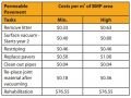
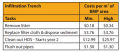
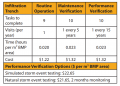
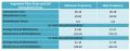
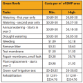 Task Cost estimates.PNG 645 × 639; 109 KB
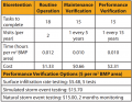
 Task cost estimates p.p.JPG 657 × 493; 70 KB
 Task cost underground.PNG 663 × 286; 40 KB
 Temp. depth pond.png 1,024 × 382; 147 KB
 Temporal changes (5-yr median) 1966 - 2022.jpg 2,550 × 1,650; 1.08 MB
 Tension infilt data log.PNG 564 × 611; 903 KB
 Terra Cotta.PNG 811 × 394; 559 KB
- Test2.pdf ; 12 KB
 Test pit.jpg 1,236 × 773; 72 KB
 Thermal load reduction LID.PNG 1,072 × 740; 297 KB
 Theta.jpg 849 × 359; 21 KB
- Thornthwaite1957.pdf ; 9.75 MB
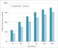 Thunder Bay and Toronto.png 928 × 766; 39 KB
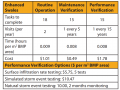
 Time & cost estimates underground.PNG 682 × 488; 75 KB
 Time commit cost.PNG 873 × 676; 110 KB
 Time commit cost swale.PNG 906 × 683; 111 KB
 Time commit costs RWH.PNG 767 × 428; 55 KB
- Tiner 2014.pdf ; 2.88 MB
 Topsoil depth.jpg 560 × 420; 75 KB
 Toronto Botanical Garden Jen.jpg 4,608 × 3,456; 4.91 MB
 Treatment train air force.JPG 1,296 × 294; 73 KB
 Treatmenttrain TRCA.JPG 738 × 479; 54 KB
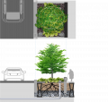
 Tree-trench+section+c-02.jpg 1,500 × 1,941; 467 KB
 TreeTranspiration.png 591 × 712; 157 KB
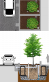
 Tree trench.PNG 495 × 377; 76 KB
- Tree trenches 2022.pdf ; 1.22 MB
- Tree trenches final.pdf ; 2.28 MB
- Tree trenches final Update.pdf ; 570 KB
 Treehealth storm.PNG 1,013 × 521; 850 KB
 Treetrench.png 1,043 × 331; 579 KB
 Trenchdrain.JPG 3,888 × 2,592; 4.26 MB
 Trimble unit.jpg 4,032 × 3,024; 7.8 MB
 Two prong method catchbasin sediment acc..PNG 508 × 618; 71 KB
 Typical Section for Swale.PNG 636 × 596; 77 KB
 Typical underground RWH.jpg 1,338 × 671; 133 KB
 U.g.rwh2.png 1,037 × 942; 819 KB
 UOIT lid.PNG 815 × 385; 667 KB
- USFHWA 2009.pdf ; 6.48 MB
 UTSC bioretention.PNG 813 × 427; 569 KB
 U of Guelph supersize rainbarrel.png 258 × 386; 142 KB
 U of Guelph underground cistern.png 363 × 365; 237 KB
 Ultra urban bioret bump out 2.jpg 1,036 × 1,353; 215 KB
 Underdrain-subgrade.jpg 4,000 × 3,000; 4.65 MB
 Underdrain-with-risers.jpg 4,000 × 3,000; 4.52 MB
 Underdrain Fail p.p.JPG 615 × 426; 43 KB
 Underdrain Pass p.p.JPG 581 × 420; 28 KB
 Underdrain bio fail.PNG 817 × 549; 804 KB
 Underdrain bio pass.PNG 774 × 549; 982 KB
 Underdrain clogded underground.PNG 514 × 388; 431 KB
 Underdrain fail underground.PNG 487 × 363; 399 KB
 Underdrain pass underground.PNG 482 × 364; 398 KB
 Unitarian Trees.JPG 3,999 × 2,415; 2.77 MB
 Unitarian congregation.PNG 806 × 381; 511 KB
 Unlabelled bioswale underdrain.png 3,900 × 1,989; 5.39 MB
- Untitled Diagram.pdf ; 25 KB
 UpbyRoots JU.png 1,062 × 776; 1.1 MB
 Update Stormwater Tree Trench Structural Panel Soil Cell.png 2,326 × 3,508; 7.73 MB
 Update Stormwater Tree Trench Structural Panel Soil Cell crop.png 2,054 × 3,410; 6.41 MB
 Updated tree trench Soil cell.png 2,600 × 2,476; 3.9 MB
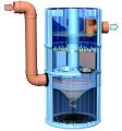 Upflow MTD.jpg 720 × 772; 83 KB
- UrbanDesignCompendium.pdf ; 6.15 MB
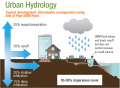 Urban Hydrology 1.png 891 × 654; 70 KB
 Urban Hydrology 2.png 906 × 665; 63 KB
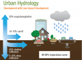 Urban Hydrology 3.png 606 × 443; 51 KB
 Urbansitedesign.png 632 × 852; 219 KB
 VFGA.png 269 × 241; 2 KB
 VFGB.png 269 × 241; 2 KB
 VFGC.png 270 × 241; 3 KB
 VFGD.png 269 × 241; 3 KB
 Vancouver Waterfront.PNG 931 × 697; 1.45 MB
 Veg Cover Fail swale.PNG 559 × 408; 576 KB
 Veg Cover Pass swale.PNG 552 × 417; 586 KB
 Veg Fail p.p.JPG 608 × 441; 62 KB
 Veg Pass p.p.JPG 608 × 442; 87 KB
 Veg filter LCCT.JPG 1,424 × 559; 123 KB
 Veg filter residential.PNG 298 × 229; 188 KB
 Veg filter road.PNG 752 × 563; 975 KB
 Vegetated filter strip 1.jpg 760 × 570; 523 KB
 Vegetation bio fail .PNG 788 × 595; 1.37 MB
 Vegetation bio pass.PNG 794 × 594; 1.34 MB
 Vegetation grass fail.JPG 622 × 433; 51 KB
 Vegetation grass pass.JPG 610 × 438; 65 KB
 Vibratory-screed-2.jpg 624 × 468; 101 KB
 Vibratory-screed.png 341 × 388; 330 KB
 Visual indicator bioretention.PNG 815 × 606; 1.24 MB
 Vitis riparia.jpg 500 × 375; 103 KB
 WHPA cartoon.png 615 × 733; 1.24 MB
 Water test permeabel pavement.PNG 1,171 × 661; 1.15 MB
 Waterfrontsoilcell DeepRoot.PNG 1,133 × 865; 2.06 MB
 Waterquality CVC Gauge.JPG 1,251 × 701; 142 KB
 Weir TTT.png 158 × 76; 4 KB
 Wet swale.png 1,782 × 942; 1.09 MB
 Wetland.PNG 812 × 381; 285 KB
 Wetland water balance.PNG 1,000 × 476; 197 KB
 Wheelwright Aug 15 2012 (14) 550x550.jpg 550 × 550; 211 KB
 Wishingwellpark.png 3,097 × 1,272; 6.88 MB
 Wood based compost.jpg 1,612 × 1,612; 958 KB
 Wood chip mulch.jpg 512 × 384; 107 KB
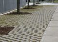
 Wychwood Permeable Pavers.jpg 3,264 × 1,836; 2.36 MB
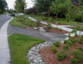
 Wychwood Subdivision Brampton rain garden.JPG 4,608 × 3,456; 6.12 MB
 Y-junction design detail.png 315 × 218; 36 KB
 Yarrow Guttman.jpg 1,024 × 715; 360 KB
 YorkU1.jpg 2,592 × 1,936; 3.31 MB
 YorkU2.jpg 2,331 × 1,813; 2.82 MB


_1966_-_2022.jpg)


_550x550.jpg)


