Difference between revisions of "Swales"
Dean Young (talk | contribs) |
|||
| Line 9: | Line 9: | ||
'''Grass swales''' are a relatively common landscape feature already and a great opportunity for retrofit, to reduce flow and improve water quality by encouraging settling and infiltration behind a series of check dams. <br> | '''Grass swales''' are a relatively common landscape feature already and a great opportunity for retrofit, to reduce flow and improve water quality by encouraging settling and infiltration behind a series of check dams. <br> | ||
'''[[Retention swales]]''' can be imagined as linear, sloped [[dry ponds]]. They typically make relatively small contributions to water volume and quality control than many other BMPs, but they may feature as part of a site-wide treatment train approach. | '''[[Retention swales]]''' can be imagined as linear, sloped [[dry ponds]]. They typically make relatively small contributions to water volume and quality control than many other BMPs, but they may feature as part of a site-wide treatment train approach. | ||
| + | |||
| + | |||
| + | Take a look at the downloadable Enhanced Grass Swales Factsheet below for a .pdf overview of this LID Best Management Practice: | ||
| + | |||
| + | {{Clickable button|[[File:Enhanced swale.png|150 px|link=https://wiki.sustainabletechnologies.ca/images/e/ef/Swales_final.pdf]]}} | ||
| + | |||
| + | |||
{{float right|{{#widget:YouTube|id=8b3-a_Na1dE}}}} | {{float right|{{#widget:YouTube|id=8b3-a_Na1dE}}}} | ||
{{textbox|Swales are an ideal technology for: | {{textbox|Swales are an ideal technology for: | ||
Revision as of 17:46, 22 October 2021

This article is about installations designed to capture and convey surface runoff along a vegetated channel, whilst also promoting infiltration.
For underground conveyance systems which promote infiltration, see Exfiltration trenches.
Overview[edit]
Swales are linear landscape features consisting of a drainage channel with gently sloping sides. Underground they may be filled with engineered soil and/or contain a water storage layer of coarse gravel material. Two variations on a basic swale are recommended as low impact development strategies, although using a combination of both designs may increase the benefits:
Bioswales are sometimes referred to as 'dry swales', 'vegetated swales', or 'water quality swales'. This type of BMP is form of bioretention with a long, linear shape (surface area typically >2:1 length:width) and a slope which convey water,
Enhanced grass swales are a lower maintenance alternative, but generally have lower stormwater management potential. The enhancement over a basic grass swale is in the addition of check dams to slow surface water flow and create small temporary pools of water which can infiltrate the underlying soil.
Grass swales are a relatively common landscape feature already and a great opportunity for retrofit, to reduce flow and improve water quality by encouraging settling and infiltration behind a series of check dams.
Retention swales can be imagined as linear, sloped dry ponds. They typically make relatively small contributions to water volume and quality control than many other BMPs, but they may feature as part of a site-wide treatment train approach.
Take a look at the downloadable Enhanced Grass Swales Factsheet below for a .pdf overview of this LID Best Management Practice:

Swales are an ideal technology for:
- Sites with long, linear landscaped areas, such as parking lots
- Connecting with one or more other types of LID
| Property | Bioswale | Enhanced grass swale |
|---|---|---|
| Surface water | Minimal Any surface flow can be slowed with check dams |
Ponding is encouraged with check dams |
| Soil | Filter media required | Amendment preferable when possible |
| Underdrain | Common | Uncommon |
| Maintenance | Medium to high | Low |
| Stormwater benefit | High | Moderate |
| Biodiversity benefit | Increased with native planting | Typically lower |
Planning Considerations[edit]


A linear design (surface area typically >2:1 length:width) is a common feature of swales:
- An absolute minimum width of 0.6 m is required for bioswales to promote healthy plant growth, and to facilitate construction,
- Grassed swales are usually mown as part of routine maintenance, so the cross section will be triangular or trapezoidal in shape with maximum side slopes of 1:3. The minimum width for this type would be 2 m. See Best cross sections
Swales may be graded along longitudinal slopes between 0.5 - 6 %:
- Between 1 - 6 %, check dams are recommended to bring the compensation gradient <1 %.
- Slopes > 6% can accommodate a series of stepped bioretention cells, each overflowing into the next with a spillway.
Design[edit]

Pretreatment and inlets
To minimize erosion and maximize the functionality of the swale, sheet flow of surface water should be directed into the side of the BMP. Gravel diaphragms, vegetated filter strips and shallow side slopes are ideal. Alternatively, a series of curb inlets can be employed, where each has some form of flow spreader incorporated. Single point inflow can cause increased erosion and sedimentation, which will damage vegetation and contribute to BMP failure. Again, flow spreading devices can mitigate these processes, where concentrated point inflow is required.
Performance[edit]
A review of swale-like practices was published by STEP in 1999. The project page and additional tools are available here.
Bioswales[edit]
While few field studies of the pollutant removal capacity of bioswales are available from cold climate regions like Ontario, it can be assumed that they would perform similar to bioretention cells. Bioretention provides effective removal for many pollutants as a result of sedimentation, filtering, plant uptake, soil adsorption, and microbial processes. It is important to note that there is a relationship between the water balance and water quality functions. If a bioswale infiltrates and evaporates 100% of the flow from a site, then there is essentially no pollution leaving the site in surface runoff. Furthermore, treatment of infiltrated runoff will continue to occur as it moves through the native soils.
| LID Practice | Location | Runoff Reduction* | Reference |
|---|---|---|---|
| Bioswale without underdrain | Washington | 98% | Horner et al. (2003)[1] |
| Scotland | 94% | Jefferies (2005)[2] | |
| Bioswale with Underdrain | Maryland | 46 to 54% | Stagge (2006)[3] |
| Bioretention without underdrain | China | 85 to 100%* | Gao, et al. (2018)[4] |
| Connecticut | 99% | Dietz and Clausen (2005) [5] | |
| Pennsylvania | 80% | Ermilio (2005)[6] | |
| Pennsylvania | 70% | Emerson and Traver (2004)[7] | |
| Bioretention with underdrain | |||
| Ontario | 64% | CVC (2020)[8] | |
| Maryland and North Carolina | 20 to 50% | Li et al. (2009) [9] | |
| North Carolina | 40 to 60% | Smith and Hunt (2007)[10] | |
| North Carolina | 33 to 50% | Hunt and Lord (2006) [11] | |
| Runoff Reduction Estimate* | 85% without underdrain;
45% with underdrain | ||
Enhanced grass swales[edit]
Construction[edit]
Galleries[edit]
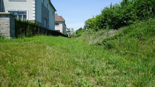
Simple grass swales[edit]
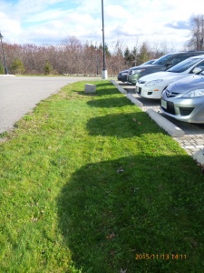
Grass swale in CVC headquarters parking lot, Mississauga ON
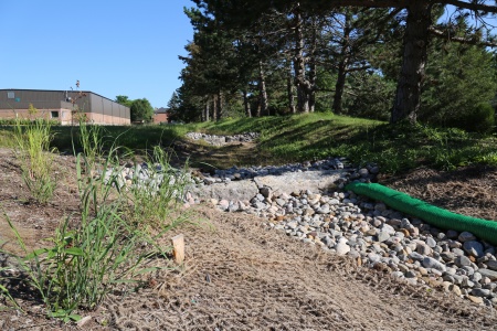
Water distributed into a wide grass swale with a rock level spreader
Flow in this wide swale is being reduced by taller vegetation on some sections (See Manning's n)


Bioswales[edit]

Streetside swale in Seattle
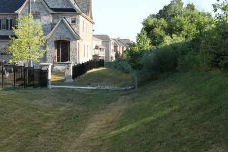
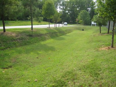
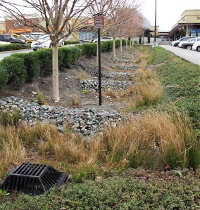
This feature is a bioswale in that the underlying soil has been replaced with engineered filter media. The turf finish simplifies landscape maintenance. Brampton, ON
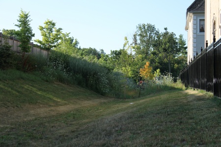
A bioswale located on Country Court Blvd., located in Brampton, ON> Read more about the performance of this feature and associated rpoject, by reading the following Grey to Green Conference Presentation, 2018. Dean Young - STEP, 2018
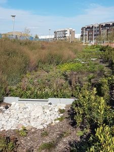
Bioswale located in Downsview Park, Toronto ON. with Check dams.
Grassed bioswale with Vegetated filter strips
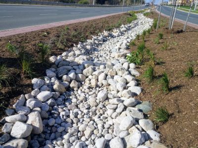
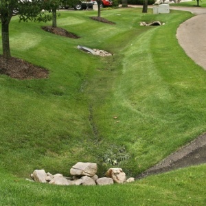
Stone-lined bioswale with rock check dams located to helps slow the flow of water as it enter the system from the nearby roads. [[ STEP, 2017

.jpg)


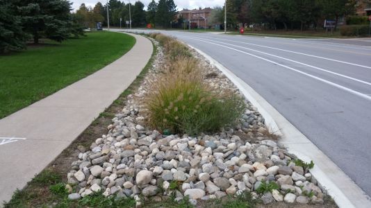
Check dams[edit]
Enhanced swale with rocky check dams and a metal overflow grate in Northgate Mall parking lot, Seattle. Photo credit: MLSmith
Bioswale with rock check dams to slow down the water, encouraging infiltration. Note the biodegradable erosion control blanket still in place. LSRCA headquarters, 2017
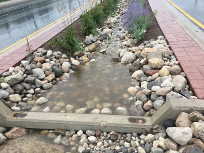
A check dam in action, effectively pooling water.
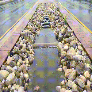
A swale during a rain event, with concrete check dams, armourstone, mulch and Tall grasses to slow down moving water (as shown in the .gif file) to promote infiltration in the feature.


Also see Jen's Pinterest board of check dams
See Also[edit]
- ↑ Horner RR, Lim H, Burges SJ. HYDROLOGIC MONITORING OF THE SEATTLE ULTRA-URBAN STORMWATER MANAGEMENT PROJECTS: SUMMARY OF THE 2000-2003 WATER YEARS. Seattle; 2004. http://citeseerx.ist.psu.edu/viewdoc/download?doi=10.1.1.365.8665&rep=rep1&type=pdf. Accessed August 11, 2017.
- ↑ Jefferies, C. 2004. Sustainable drainage systems in Scotland: the monitoring programme. Scottish Universities SUDS Monitoring Project. Dundee, Scotland. https://www.climatescan.nl/uploads/projects/8126/files/1277/SNIFFERSR_02_51MainReport.pdf
- ↑ Stagge, J. 2006. Field evaluation of hydrologic and water quality benefits of grass swales for managing highway runoff. Master of Science Thesis, Department of Civil and Environmental Engineering, University of Maryland. https://drum.lib.umd.edu/items/42be6ce6-e4ef-4162-a991-c273607d422d
- ↑ Gao, J., Pan, J., Hu, N. and Xie, C., 2018. Hydrologic performance of bioretention in an expressway service area. Water Science and Technology, 77(7), pp.1829-1837.
- ↑ Dietz, M.E. and J.C. Clausen. 2005. A field evaluation of rain garden flow and pollutant treatment. Water Air and Soil Pollution. Vol. 167. No. 2. pp. 201-208. http://citeseerx.ist.psu.edu/viewdoc/download?doi=10.1.1.365.9417&rep=rep1&type=pdf
- ↑ Ermilio, J.F., 2005. Characterization study of a bio-infiltration stormwater BMP (Doctoral dissertation, Villanova University). https://www1.villanova.edu/content/dam/villanova/engineering/vcase/vusp/Ermilio-Thesis06.pdf
- ↑ Emerson, C., Traver, R. 2004. The Villanova Bio-infiltration Traffic Island: Project Overview. Proceedings of 2004 World Water and Environmental Resources Congress (EWRI/ASCE). Salt Lake City, Utah, June 22 – July 1, 2004. https://ascelibrary.org/doi/book/10.1061/9780784407370
- ↑ Credit Valley Conservation. 2020. IMAX Low Impact Development Feature Performance Assessment. https://sustainabletechnologies.ca/app/uploads/2022/03/rpt_IMAXreport_f_20220222.pdf
- ↑ Li, H., Sharkey, L.J., Hunt, W.F., and Davis, A.P. 2009. Mitigation of Impervious Surface Hydrology Using Bioretention in North Carolina and Maryland. Journal of Hydrologic Engineering. Vol. 14. No. 4. pp. 407-415.
- ↑ Smith, R and W. Hunt. 2007. Pollutant removals in bioretention cells with grass cover. Proceedings 2nd National Low Impact Development Conference. Wilmington, NC. March 13-15, 2007.
- ↑ Hunt, W.F. and Lord, W.G. 2006. Bioretention Performance, Design, Construction, and Maintenance. North Carolina Cooperative Extension Service Bulletin. Urban Waterways Series. AG-588-5. North Carolina State University. Raleigh, NC.